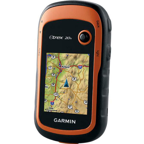
About Garmin eTrex 20x
Select the Garmin eTrex 20x for phenomenal outdoor navigation, decorated with precision engineering and unmatchable features. Explore the wild effortlessly using its high-sensitivity quad helix antenna, preloaded worldwide basemap, and instant satellite acquisition with <3m accuracy. Store up to 2,000 waypoints and 200 routes with instant savings on memory via a microSD expansion slot. This handheld GPS provides up to 25 hours of power and robust IPX7 water resistance, making it perfect for hiking, trekking, or fieldwork. Its vibrant 2.2" color display, seamless data transfer via USB, and geocaching support ensure you never miss an adventure.
Versatile Outdoor Navigation - Wherever You Explore
The Garmin eTrex 20x excels in diverse applications, including hiking, trekking, geocaching, fieldwork, and personal navigation. Its worldwide GPS coverage and robust construction allow use across multiple terrains and climates, from mountain trails to forest expeditions. With a customizable interface and instant satellite acquisition, users can enjoy streamlined navigation and reliable accuracy. The eTrex 20x stands out with its unmatchable durability and adaptability, offering phenomenal performance for adventurers and professionals alike.
Domestic and Export Markets - Fast Dispatch, Flexible Samples
Garmin eTrex 20x is widely offered across the Indian domestic market, catering to explorers, researchers, and outdoor enthusiasts. Promptly dispatched upon confirmed purchase order, it is available for sample assessment per policy. International traders and suppliers benefit from instant order handling and shipping to various global destinations. Whether for export or local distribution, the eTrex 20x upholds reliability and quality-making it a trusted choice in both domestic and overseas markets.
FAQ's of Garmin eTrex 20x:
Q: How accurate is the Garmin eTrex 20x for outdoor navigation?
A: The Garmin eTrex 20x uses a high-sensitivity GPS receiver and quad helix antenna, offering GPS accuracy within less than 3 meters under typical conditions, ensuring precise tracking for all outdoor activities.
Q: What types of maps are supported by the eTrex 20x?
A: This device supports a wide array of maps, including preloaded worldwide basemap, Garmin TOPO, BlueChart, City Navigator, and BirdsEye Satellite Imagery. You can expand map storage using a microSD card (up to 32 GB).
Q: When should I replace the batteries in the eTrex 20x?
A: The eTrex 20x operates on two AA batteries (not included) and provides up to 25 hours of usage. Replace batteries when the power indicator is low to ensure continuous navigation.
Q: Where can I use the eTrex 20x for navigation?
A: The device is designed for worldwide usage, including hiking trails, city navigation, and diverse fieldwork environments, thanks to its waterproof IPX7 rating and rugged build.
Q: What is the process for updating my Garmin eTrex 20x maps and software?
A: Updates for maps and software are completed via mini-USB connection and Garmin software on your computer. Follow on-screen instructions for seamless data transfer.
Q: How does the TrackBack feature benefit my outdoor expeditions?
A: TrackBack allows you to retrace your route back to your starting point, increasing safety and convenience during complex hikes or treks.


 Send Inquiry
 Call Me Free