About
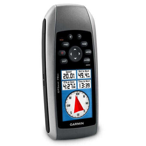
This is your Last Chance to own the remarkable Garmin GPSMAP 78s-a highly popular handheld GPS device, renowned for its robust IPX7 waterproof design and accurate global navigation. Remarked for its versatility, it supports 2,000 waypoints, 200 routes, and 10,000 track log points. The 3-axis, tilt-compensated electronic compass, and barometric altimeter ensure outstanding precision. With up to 20 hours battery life and wireless data transfer, this floatable device is perfect for marine and outdoor adventurers. Order Today and experience navigation that's truly dependable.
Superior Navigation for Diverse Terrains
Garmin GPSMAP 78s is ideal for outdoor navigation, marine use, and geocaching activities. Its application surface spans rainy rivers, rugged mountain trails, and dense forests, making it a trusted companion in challenging environments. Used for real-time wayfinding and tracking, its primary advantage lies in remarkable accuracy (<10 m), floatable construction, and sunlight-readable TFT screen, ensuring reliable performance in any situation. Choose this device for comprehensive global coverage and precise route management wherever adventure takes you.
Packaging, Dispatch, and Export Assurance
We estimate prompt freight and secure packing & dispatch for each Garmin GPSMAP 78s, safeguarding the remarkable build through transit. The product is delivered in certified, robust packaging with thorough documentation for international compliance. Main export markets include India and other key global regions. Our packaging team ensures devices remain protected against humidity, vibration, and temperature fluctuations, maintaining product integrity from warehouse to final destination. Experience seamless export quality and trusted dispatch every order.
FAQ's of Garmin GPSMAP 78s:
Q: How does the Garmin GPSMAP 78s benefit outdoor and marine navigation?
A: The Garmin GPSMAP 78s offers precise navigation with advanced sensors, global map compatibility, a floatable build, and rugged waterproofing, making it ideal for both outdoor and marine use.
Q: What is the process for sharing waypoints or routes wirelessly?
A: You can wirelessly transfer waypoints, routes, and tracks to compatible Garmin devices using the built-in wireless sharing feature. Simply enable wireless mode and follow on-screen prompts for a swift transfer.
Q: Where can the Garmin GPSMAP 78s be used effectively?
A: The device excels in diverse environments, including rivers, lakes, forests, mountains, and marine contexts, thanks to its IPX7 waterproofing and floatable design.
Q: When should I use the electronic compass and barometric altimeter?
A: Use the electronic compass for accurate heading information even when standing still, and the barometric altimeter for elevation tracking and weather trend monitoring during outdoor activities.
Q: How accurate is the GPS positioning and how quickly does it acquire waypoints?
A: The GPSMAP 78s provides position accuracy of less than 10 meters (or 3-5 meters with WAAS) and can acquire waypoints in less than one second, ensuring quick and reliable navigation.


 విచారణ పంపండి
 నాకు ఉచితంగా కాల్ చేయండి