Back to top

Garmin GPSMAP 64s

Garmin GPSMAP 64s
Garmin GPSMAP 64s

Garmin GPSMAP 64s Specification

  • Power Supply
  • 2 x AA batteries (NiMH or Lithium recommended)
  • Display Type
  • 2.6 sunlight-readable transflective color TFT
  • Response Time
  • <1 second update rate
  • Accuracy
  • GPS: <10 m RMS, with WAAS <3 m
  • Interface Type
  • USB, NMEA 0183
  • Automation Grade
  • Manual
  • Mounting Type
  • Handheld or optional vehicle mount
  • Equipment Type
  • Handheld GPS Device
  • Application
  • Navigation, hiking, trekking, mapping, geocaching
  • Operating Voltage
  • 2.5 V to 3.0 V (via USB or batteries)
  • Features
  • GLONASS support, electronic compass, barometric altimeter, wireless data sharing, water resistant (IPX7), paperless geocaching, expandable memory
  • Temperature
  • -20C to 70C
  • Humidity
  • Operating: up to 90% (non-condensing)
  • Port Size
  • Micro USB
  • Resolution
  • 160 x 240 pixels
  • Usage
  • Outdoor GPS navigation
  • Capacity
  • Memory can store 5,000 waypoints, 200 routes, 10,000 points per track, 200 saved tracks
  • Machine Weight
  • 230 g with batteries
  • Control Mode
  • Manual buttons and joystick
  • Electronic Compass
  • Yes (3-axis)
  • Water Rating
  • IPX7
  • Map Compatibility
  • Supports TOPO, BirdsEye Satellite Imagery, City Navigator, custom maps
  • Wireless Data Transfer
  • Yes (ANT+)
  • Custom POIs
  • Yes
  • Languages Supported
  • Multiple
  • Barometric Altimeter
  • Yes
  • Antenna
  • Helical
  • Track Log
  • 10,000 points, 200 saved tracks
  • Preloaded Maps
  • Worldwide basemap
  • System Memory
  • 4 GB internal, expandable via microSD
  • Geocaching-Friendly
  • Yes, paperless
  • Unit-to-Unit Transfer
  • Yes
  • Battery Life
  • up to 16 hours
  • Dimensions
  • 6.1 x 16.0 x 3.6 cm
  • Waypoints
  • 5000
  • Color Display
  • Yes


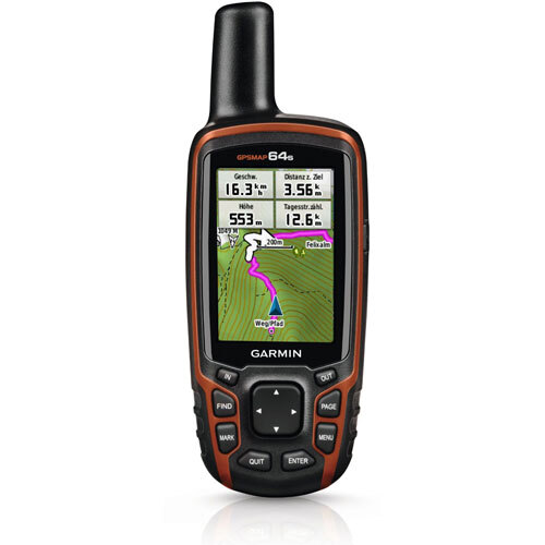
About Garmin GPSMAP 64s


Discover the fresh, top-ranking Garmin GPSMAP 64s-a must-have handheld GPS device for outdoor adventurers and professionals alike. Boasting remarkable accuracy with GPS and GLONASS support, this terrific unit features a color display for clear readings under any lighting. Preloaded worldwide maps, water resistance (IPX7), and robust build ensure durability and reliability on every trek. Enjoy remarkable flexibility with custom POIs, wireless data transfer, and expandable memory at the lowest price in its segment. Don't miss this all-weather navigation powerhouse!

Exceptional Outdoor Navigation & Usage

The Garmin GPSMAP 64s offers effortless direction for hikers, trekkers, and geocachers, enhanced by its user-friendly manual controls, sunlight-readable display, and 3-axis compass. This compact tool is ideal for various commercial mapping and surveying applications, while remarkable special features like a barometric altimeter and wireless data transfer ensure ultimate reliability on the trail. Follow simple button and joystick directions for precise guidance wherever your journey leads.


Fast Shipping & Clear Transaction Policies

Garmin GPSMAP 64s orders are shipped quickly for customer convenience, with prompt dispatch from the nearest location. Payment terms accommodate varied business needs-quotations offered on request. FOB port is typically based in India, ensuring easy logistics. Sample policies allow buyers to assess model suitability prior to bulk orders, making the process smooth and dependable. Choose the GPSMAP 64s for efficient delivery and transparent transactions at unbeatable prices.


FAQ's of Garmin GPSMAP 64s:


Q: How do I operate the Garmin GPSMAP 64s for hiking or navigation?

A: Simply power the device using 2 AA batteries, select your preferred map, and use the manual buttons and joystick to set waypoints or follow saved tracks. The built-in compass and barometric altimeter help guide you reliably.

Q: What commercial uses is the Garmin GPSMAP 64s suited for?

A: This GPS is perfect for outdoor navigation, hiking, mapping, trekking, and geocaching. It's also valuable for surveying and GIS data collection due to its accuracy and detailed mapping compatibility.

Q: Where can I store and manage points, tracks, and routes?

A: With a 4 GB internal memory and microSD slot, you can store up to 5,000 waypoints, 200 routes, and 200 tracks. Data management is easy, thanks to customizable options and wireless transfer capabilities.

Q: When should I use the wireless data transfer feature?

A: Utilize wireless data transfer via ANT+ when you need to share waypoints, tracks, or geocaching details with other compatible GPSMAP units-ideal for group activities or team missions.

Q: What are the benefits of the GPSMAP 64s in extreme weather?

A: Engineered with an IPX7 water rating and a wide operating temperature range (-20C to 70C), the unit guarantees seamless function even in harsh outdoor conditions, ensuring navigation reliability in any scenario.

Tell us about your requirement
product

Price:

Quantity
Select Unit

  • 50
  • 100
  • 200
  • 250
  • 500
  • 1000+
Additional detail
Mobile number

Email

More Products in Survey Instruments Category

Topcon-GM-52-thumbs TOTAL STATION

Topcon-GM-52-thumbs TOTAL STATION

Price 500000 INR / Number

Minimum Order Quantity : 1 Number

Application : Land Survey, Construction, Civil Engineering

Response Time : Fast measurement < 0.9 seconds

Machine Weight : Approx. 5.1 kg including battery and tribrach

Automation Grade : Manual

Garmin eTrex 32x

Garmin eTrex 32x

Price 32990 INR / Number

Minimum Order Quantity : 1 Number

Application : Outdoor navigation, hiking, cycling, geocaching

Response Time : Instant on GPS lock (typically several seconds)

Machine Weight : 141.7 g (with batteries)

Automation Grade : Manual operation

Garmin GPSMAP 78s

Garmin GPSMAP 78s

Price 32990 INR / Number

Minimum Order Quantity : 1 Number

Application : Outdoor navigation, marine navigation, geocaching

Response Time : <1 second waypoint acquisition

Machine Weight : 218.3 g

Automation Grade : Manual

Leica Disto D810 a   200m Range

Leica Disto D810 a 200m Range

Price 84990 INR / Number

Minimum Order Quantity : 1 Number

Application : Distance measurement, area and volume calculation, documentation, measurement of objects in pictures

Response Time : Typically < 0.5 seconds

Machine Weight : 238 g (with batteries)

Automation Grade : Manual