About Garmin GPSMAP 78
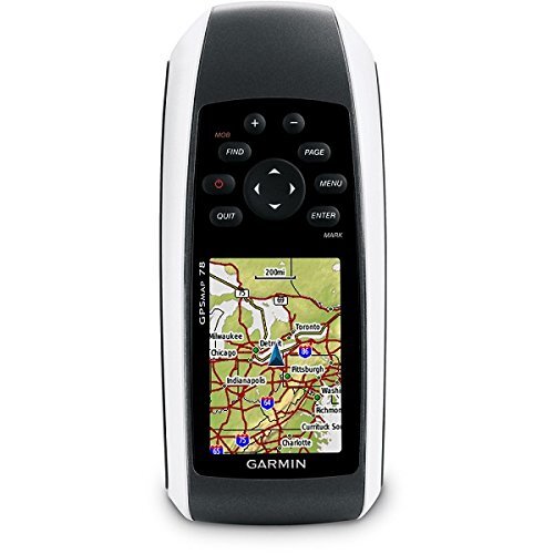
Spotlight the redoubtable Garmin GPSMAP 78, a polished and first-rate handheld GPS navigator built for those who demand reliability and accuracy on every adventure. Jump on this opportunity to advance purchase a device featuring worldwide measuring range, a substantial 1.7 GB memory, and support for custom maps. With its robust IPX7 waterproof floating design, high-sensitivity receiver, and up to 20 hours of battery life, the GPSMAP 78 stands out as your ideal companion for marine, hiking, and geocaching explorations. Its intuitive keypad control, USB connectivity, and extensive waypoint storage empower efficient navigation and position management in all environments.
Wide-Ranging Application and Suitability
The Garmin GPSMAP 78 excels in outdoor navigation, making it highly suitable for marine expeditions, hiking trails, and geocaching excursions. Used as a handheld waypoint manager and navigation aid, this device is engineered for navigation, position marking, and waypoint management, ensuring reliable performance for enthusiasts and professionals alike. Its robust features and versatility position it as the go-to equipment for precise, real-time positioning across diverse terrain and usage scenarios.
Domestic Market, Certifications & Efficient Service
The Garmin GPSMAP 78 holds a strong market value in India's main domestic market, serving clients through reliable dispatching and comprehensive transport services. With proper manufacturer certifications ensuring quality, payment terms can be arranged for customer convenience. Swift order processing and efficient logistics combine to deliver the product securely to your location, enhancing satisfaction and establishing trust in both product and supplier.
FAQ's of Garmin GPSMAP 78:
Q: How does the Garmin GPSMAP 78 help with outdoor navigation?
A: The GPSMAP 78 features real-time, continuous positioning and high-sensitivity reception, offering accurate wayfinding and reliable navigation for marine, hiking, or geocaching activities.
Q: What are the main benefits of the floating design?
A: The floating design ensures the device remains buoyant if dropped into water, making it ideal for marine and water-based adventures while protecting your investment.
Q: Where can the GPSMAP 78 be used effectively?
A: Its robust build, waterproof rating, and global GPS coverage make it suitable for use in harsh outdoor environments such as mountains, lakes, and dense forests throughout worldwide locations.
Q: What is the process for managing waypoints and routes?
A: Using its polished keypad interface, users can store up to 2,000 waypoints and 200 routes, ensuring efficient organization and customization for repeat journeys or complex trips.
Q: How is the device powered and what is its battery life?
A: The unit operates on two AA batteries (not included) and delivers up to 20 hours of continuous use, allowing for extended excursions without frequent recharging.


 Send Inquiry
 Call Me Free